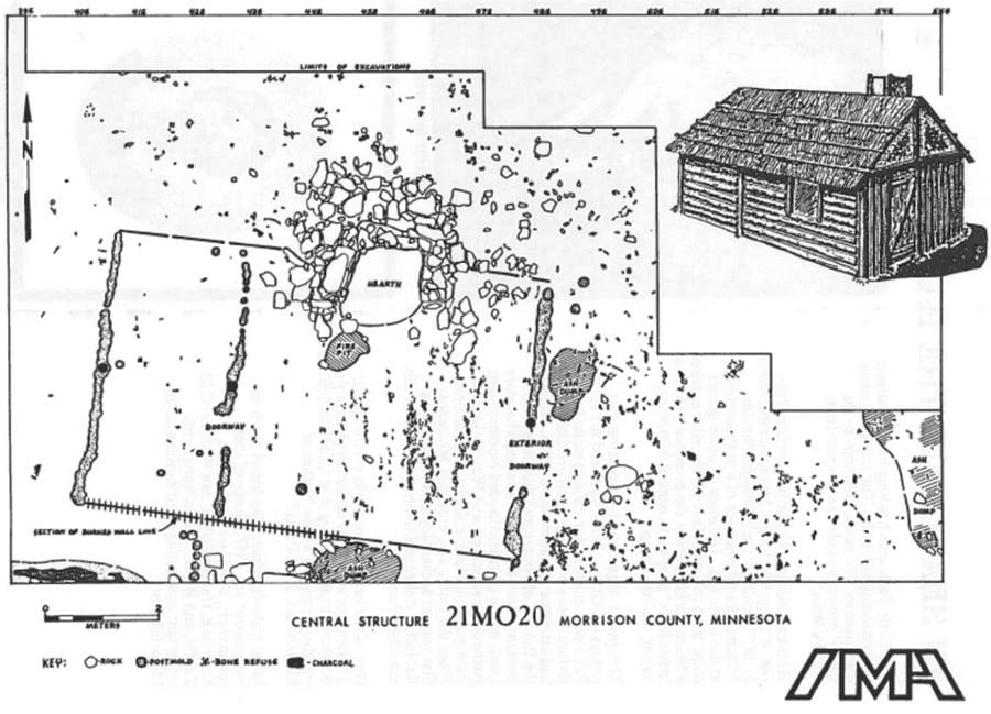
21-MO-20 (archaeological site)

Bibliography
Birk, Douglas. “French Presence in Minnesota: The View from Site MO20 Near Little Falls.” In French Colonial Archaeology: the Illinois Country and the Western Great Lakes, edited by John A. Walthall, 237–266. University of Illinois Press, 1991.
Douglas A. Birk archaeology papers, 1958-2017
Department of Anthropology, St. Cloud State University, St. Cloud
Description: The collection contains the professional work papers of Minnesota historical archaeologist Douglas A. Birk as well as Birk’s research library and the 21-MO-20 archaeological collection.
https://stcloudstate.libraryhost.com/index.php/douglas-a-birk-archaeology-papers
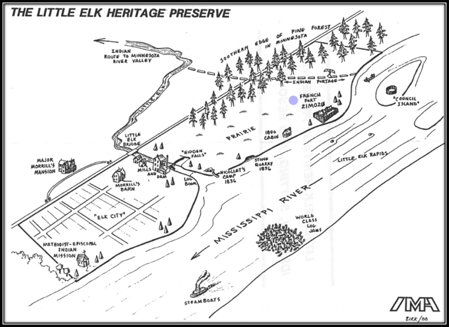
Mann, Rob. “Life, Land, Water, and Time: Archaeologist Doug Birk and the Little Elk Heritage Preserve.” Open Rivers: Rethinking Water, Place and Community no. 12 (Fall 2018) 28–36.
https://openrivers.lib.umn.edu/article/life-land-water-and-time-archaeologist-doug-birk
——— . “The Light and the Heat: Evidence of Godliness, Domesticity, and Colonial Encounters at the Little Elk Mission.” Minnesota Archaeologist 81 (2024): 101–112.
Minnesota Archaeological Society. “French or British: Identifying the 18th Century Ceramics from a Minnesota Fur Trade Post.” YouTube video recorded on November 28, 2023. https://www.youtube.com/watch?v=nGfpqSUAo4w
Minnesota Parks and Trails Organization. Charles A. Lindbergh State Park.
https://parksandtrails.org/state-parks/charles-lindbergh/https://parksandtrails.org/state-parks/charles-lindbergh
Nassaney, Michael S. The Archaeology of the North American Fur Trade. University Press of Florida, 2015.
National Park Service. Joseph Nicollet.
https://www.nps.gov/people/joseph-nicollet.htm
Nute, Grace Lee. "Posts in the Minnesota Fur-Trading Area, 1660–1855." Minnesota History 11, no. 4 (1930): 353–385.
https://www.mnhs.org/hubfs/sites/default/files/exhibits-to-go/fur-trade/educational-resources/posts-mn-fur-trade.pdf
——— . The Voyageur. Minnesota Historical Society, 1955.
——— . The Voyageur's Highway: Minnesota's Border Lake Land. Minnesota Historical Society, 1941.
Office of the State Archaeologist of Minnesota. Contact Period: An Overview of Contact Period Archaeology in Minnesota (1650–1837.
https://mn.gov/admin/archaeologist/the-public/mn-archaeology/contact-period
Smithsonian Institute Archives. Nicollet Expedition (1838, 1839).
https://siarchives.si.edu/collections/auth_exp_fbr_eace0027
Related Images


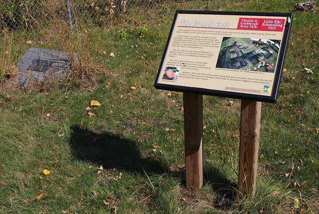
Historical sign and marker at 21-MO-20
Holding Location
More Information
Chronology
400 BCE
1679
1737
1750s–1770s
1750s and/or 1760s
1838
1841
1960s
1978
1980s
1984
1985
1988
2003
2003
2023
Bibliography
Birk, Douglas. “French Presence in Minnesota: The View from Site MO20 Near Little Falls.” In French Colonial Archaeology: the Illinois Country and the Western Great Lakes, edited by John A. Walthall, 237–266. University of Illinois Press, 1991.
Douglas A. Birk archaeology papers, 1958-2017
Department of Anthropology, St. Cloud State University, St. Cloud
Description: The collection contains the professional work papers of Minnesota historical archaeologist Douglas A. Birk as well as Birk’s research library and the 21-MO-20 archaeological collection.
https://stcloudstate.libraryhost.com/index.php/douglas-a-birk-archaeology-papers
Mann, Rob. “Life, Land, Water, and Time: Archaeologist Doug Birk and the Little Elk Heritage Preserve.” Open Rivers: Rethinking Water, Place and Community no. 12 (Fall 2018) 28–36.
https://openrivers.lib.umn.edu/article/life-land-water-and-time-archaeologist-doug-birk
——— . “The Light and the Heat: Evidence of Godliness, Domesticity, and Colonial Encounters at the Little Elk Mission.” Minnesota Archaeologist 81 (2024): 101–112.
Minnesota Archaeological Society. “French or British: Identifying the 18th Century Ceramics from a Minnesota Fur Trade Post.” YouTube video recorded on November 28, 2023. https://www.youtube.com/watch?v=nGfpqSUAo4w
Minnesota Parks and Trails Organization. Charles A. Lindbergh State Park.
https://parksandtrails.org/state-parks/charles-lindbergh/https://parksandtrails.org/state-parks/charles-lindbergh
Nassaney, Michael S. The Archaeology of the North American Fur Trade. University Press of Florida, 2015.
National Park Service. Joseph Nicollet.
https://www.nps.gov/people/joseph-nicollet.htm
Nute, Grace Lee. "Posts in the Minnesota Fur-Trading Area, 1660–1855." Minnesota History 11, no. 4 (1930): 353–385.
https://www.mnhs.org/hubfs/sites/default/files/exhibits-to-go/fur-trade/educational-resources/posts-mn-fur-trade.pdf
——— . The Voyageur. Minnesota Historical Society, 1955.
——— . The Voyageur's Highway: Minnesota's Border Lake Land. Minnesota Historical Society, 1941.
Office of the State Archaeologist of Minnesota. Contact Period: An Overview of Contact Period Archaeology in Minnesota (1650–1837.
https://mn.gov/admin/archaeologist/the-public/mn-archaeology/contact-period
Smithsonian Institute Archives. Nicollet Expedition (1838, 1839).
https://siarchives.si.edu/collections/auth_exp_fbr_eace0027